
CHARLOTTE — Heavy snow has moved through the Charlotte area as travel conditions remain treacherous.
Charlotte Douglas Airport officially measured 11 inches of snow. It is tied for the fourth-highest one-day total.
The bitter cold will stick around through Sunday as temperatures barely get above freezing.
0 of 26


We have reporters throughout the area to give updates on conditions, and we’re keeping an eye on the roads as snow is expected to create hazardous conditions. Stay updated on this article throughout the day Saturday and see live updates below.
11:00 p.m. - Firefighters pull car out of pond in east Charlotte
Charlotte Fire responded to a reported vehicle in the water at approximately 7:35 p.m. at the intersection of Jerimoth Drive and Cuddington Drive.
— Charlotte Fire Dept (@CharlotteFD) February 1, 2026
Fire communications received calls reporting a pickup truck had lost control, left the roadway, and entered a retention pond.… pic.twitter.com/HVSR003hGu
10:00 p.m. - Saturday night’s forecast with Chief Meteorologist John Ahrens.

9:00 p.m. - Saturday’s winter storm totals from North Carolina State Highway Patrol:
Statewide Winter Storm Totals:
— North Carolina State Highway Patrol (@NCSHP) January 31, 2026
January 31 at 12 am through
January 31 at 6 pm:
Collisions: 750
Calls for Service: 817
Weather Related Fatal Collisions: 0 pic.twitter.com/8wmT7sUWzO
8:00 p.m. - Our winter storm continues to hammer away at Charlotte but it’s starting to get entrenched with some dry air - a sign that we are almost finished. However, it will keep coming down especially on the east side for another few hours. The storm itself will finally completely pull away by 11 p.m. and we can breathe a sign of relief. But be ready for super cold conditions! It will be as cold as 10 degrees by Sunday morning.
After that tough morning, it’s all smiles! The sun will shine, the wind will be calmer and we can all be out and enjoy a snow day!
7:00 p.m. - The latest forecast with Chief Meteorologist John Ahrens.

6:05 p.m. - We have officially broken the snow record with 6.1 inches of snow reported at Charlotte International Douglas Airport.
5:45 p.m. - Interstate 85 northbound in Kannapolis is shut down following a traffic incident that left more than 100 vehicles stranded on the highway.
#BREAKING: The National Guard has been deployed to help clear over 100 vehicles stuck on I-85 NB in #Kannapolis prior to Lane St. after numerous crashes and stuck tractor trailers. More on @wsoctv #CabarrusCo #clt #cltraffic #clttraffic pic.twitter.com/Q9VoFa3S5A
— Traffic Team 9 (@TrafficTeam9) January 31, 2026
5:10 p.m. - There is a ground stop for American Airlines flights at Charlotte Douglas International Airport. It is expected to be lifted at 7 p.m.
5:05 p.m. - Charlotte snow history
A little Charlotte snow history for you. It will be interesting to see when the tallies are counted! Hope yall are enjoying the snow! pic.twitter.com/O7Xvqppagp
— John Ahrens (@JohnAhrensWSOC9) January 31, 2026
4:15 p.m. - Chief Meteorologist John Ahrens forecast
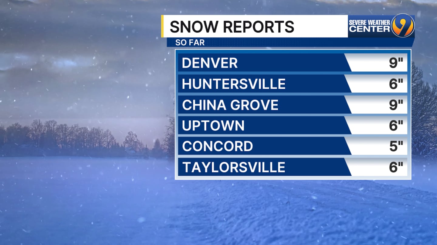
4 p.m. - Snow totals
3:30 p.m. - Tune in to watch Eyewitness News after the hockey game. Here’s where our crews are reporting from:
- Glenn Counts - Uptown Charlotte
- Jonathan Lowe - Post-Hornets game at Spectrum Center
- Meteorologist Danielle Miller - Road conditions in east Charlotte
- Hunter Sáenz - North Charlotte
- Tina Terry - Indian Land, South Carolina
- Erika Jackson - Cornelius
- Gina Esposito - Union County
- Joe Bruno - Cabarrus County and Kannapolis
- Dave Faherty - Hickory
- Ken Lemon - Outer Banks
3:15 p.m. - We have been monitoring snow totals at the Channel 9 studios using a Bojangles box. Our expectation was that we would see at least 3-6 inches. Now, we have surpassed that with about 7 inches, covering the Bojangles box.
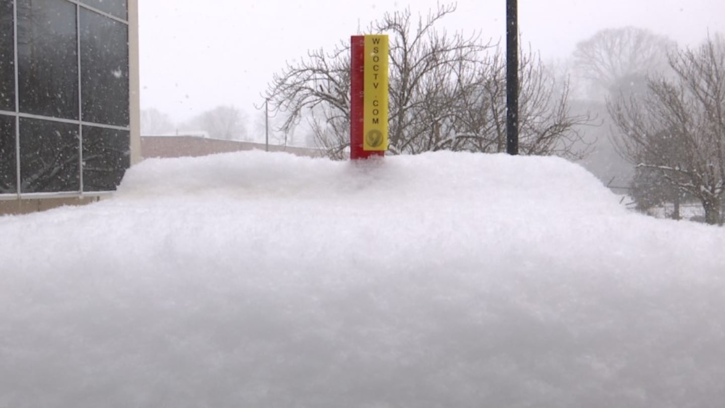
Live Bojangles Box Cam:
2:45 p.m. - Forecast update

2:35 p.m. - 23 crashes and 10 stalled/disabled vehicles on the CMPD Roadway Obstruction Report.
2 p.m. - About 6″ of snow has fallen in Uptown Charlotte, and viewers across the Carolinas have shared their experiences. From slick roads in Union County to 10″ of snow in Kannapolis and China Grove, this snowstorm has had a wide impact on North Carolina and South Carolina. The storm is expected to keep snowing until Saturday evening.
1 p.m. - CATS announced that it is shutting down service early on Saturday; bus service will end at 3 p.m., and the Blue Line will shut down at 5 p.m.
12:45 p.m. - Chief Meteorologist John Ahrens says the impact of this storm is getting bigger, and some parts of the area may see a snowfall rate up to an inch per hour. Outside of the WSOC-TV studios, we’ve already seen 5″ on our tracker.
11:30 a.m. - The city of Charlotte and Traffic Team 9’s Mark Taylor have the same warning and advice for you: If you don’t need to be on the roads, stay home.
In addition to dozens of crashes being reported, drivers are getting stuck on slippery roads that haven’t been plowed yet.
The volume of crashes is significantly higher than what we typically see during the busiest morning commutes. https://t.co/VQmvb67Trm
— Traffic Team 9 (@TrafficTeam9) January 31, 2026
11 a.m. - It’s not just road conditions that are causing delays for travelers - more than 700 flights at Charlotte-Douglas International Airport were either canceled or delayed as of 11 a.m., according to FlightAware. The majority of those flights were canceled.
Meanwhile, snow plows are working on clearing roads as quickly as they can, but we’ve heard from transportation crews that some drivers are getting stuck along the Interstate 277 exit for Davidson Street, more notoriously known as Exit 3A.
Plow trucks working together on 277!
— Hunter Sáenz (@Hunt_Saenz) January 31, 2026
Give them some room people!!! @wsoctv pic.twitter.com/mLN0uF8kEy
10:25 a.m. - Traffic Team 9’s Mark Taylor says more than 30 crashes have been reported in the Charlotte area. Some drivers are also seeing impassable roads, including a closure on Wendover Road due to slick conditions on a hill.
10 a.m. - Extended coverage of the snowstorm is starting on Channel 9 now. Tune in to watch on TV, or you can stream live at the top of this page. Here’s where you can see our crews:
- Meteorologist Danielle Miller - Road conditions in east Charlotte
- Hunter Sáenz - North Charlotte
- Tina Terry - Indian Land, South Carolina
- Erika Jackson - Cornelius
- Gina Esposito - Union County
- Joe Bruno - Cabarrus County and Kannapolis
- Dave Faherty - Hickory
- Ken Lemon - Outer Banks
277 right now near Uptown. Please do not be on the roads if you don’t have to. Side roads are very slick and snow is building up. You can’t tell what’s a road and what’s a median. @wsoctv pic.twitter.com/1QBcmNWZKI
— Hunter Sáenz (@Hunt_Saenz) January 31, 2026
You can also keep an eye on our “Snowjangles” measurement. Will we get 8″ of snow?
CATS told Channel 9 that light rail and bus service will end at midnight, and they’re suspending the Gold Line streetcar for Sunday. Micro transit will be suspended at 11 a.m.
9:30 a.m. - Wind chills are below 10 degrees now, and we’re seeing a heavy band of snow over the Charlotte area.
We’re now estimating at least 5-8″ of snow across the region, and some parts of Charlotte may even see up to 10″ of snow.
8:30 a.m. - Parts of North Carolina have already accumulated several inches of snow, and more crashes are being reported along interstates in the Charlotte area. People are urged to not drive unless necessary. Drive well below the speed limit if you have to be on the roads.
8:30 am update on the snow. pic.twitter.com/t4f5iodGUL
— Keith Monday (@kmondayWSOC9) January 31, 2026
8 a.m. - What happens when the Channel 9 Sports Director is put on snow coverage? You get pure honesty:

7:45 a.m. - Here’s a look at the roads in the Charlotte area as about an inch of snow has fallen.
0 of 10


7:30 a.m. - Update from Meteorologist Keith Monday: The snow started before 4 a.m. in Charlotte and will pick up more throughout the day. Temps continue to fall through the 20s and we’ll settle in to near 20 degrees this afternoon. Wind chills will be in the single digits. Snow totals are expected to range from 5-8” for most neighborhoods with some areas far northwest and far east receiving slightly less.
We haven’t had 4”+ of snow in nearly 12 years, but it’s been over 20 years since we had at least 8” or more!
The brutal cold then becomes the story as we see the snow wind down tonight. Lows fall to the lower teens tonight. It could end up being our coldest night since 12/24/22 with a low of 12°. We have plenty of sun tomorrow, but we only warm to near freezing and it won’t do much to melt off all the roads. It may end up even colder Monday morning with some single digits possible.
7 a.m. - About a half-inch of snow has accumulated in Charlotte already.
Will we surpass our prediction of at least 3-6″? See if the snow fills up a Bojangles box LIVE:
6:30 a.m. - Crashes are being reported along interstates and thoroughfares in Charlotte. No major road closures have been reported at this time.
Charlotte-Mecklenburg Schools announced that all programs and events are canceled for Saturday and Sunday. We’re still keeping an eye out for school districts’ plans for Monday.
5 a.m. - Our area is getting its first blast of wintry precipitation. Northern, mountainous areas of North Carolina have seen snow all night and early morning, and the winter storm is now making its way into the Charlotte metropolitan area.

>> Channel 9’s Weather 24/7 stream has the latest local weather all day, every day. Watch wherever you stream — on our website, or through your mobile app or smart TV.
WEATHER RESOURCES:
- WSOC Weather 24/7
- Interactive Radar
- Download our weather app for Severe Weather Alerts
- Hour-by-Hour Forecast
- 7-Day Forecast
FOLLOW OUR TEAM ON X:
- Chief Meteorologist John Ahrens
- Meteorologist Keith Monday
- Meteorologist Joe Puma
- Meteorologist Danielle Miller
(VIDEO: Hildebran museum floods after pipe bursts during cold weather)

©2026 Cox Media Group

/cloudfront-us-east-1.images.arcpublishing.com/cmg/LH3JSJEF3VBLRJLJQESEAG34AM.png)


