For the first time in 21 years, an Ice Storm Warning has been issued for Charlotte.
ABOVE: The latest forecast update from Severe Weather Center 9. To stay on top of changing weather conditions, be sure to download our free WSOC-TV weather app.
WINTER WARNINGS: An Ice Storm Warning has been issued for most of our area for this weekend’s storm. A Winter Storm Warning is in effect for Ashe and Watauga counties. Anson, Stanly, and Richmond will be upgraded later today.
FORECAST:
- Ice Storm and Winter Storm Warnings go into effect this afternoon as we track this winter storm moving in from the west today.
- Expect much of the daytime to be dry, with moisture moving in later this afternoon and evening.
- This will start as a snow/sleet mix in the mountains and sleet for the Piedmont, before quickly transitioning to freezing rain areawide overnight.
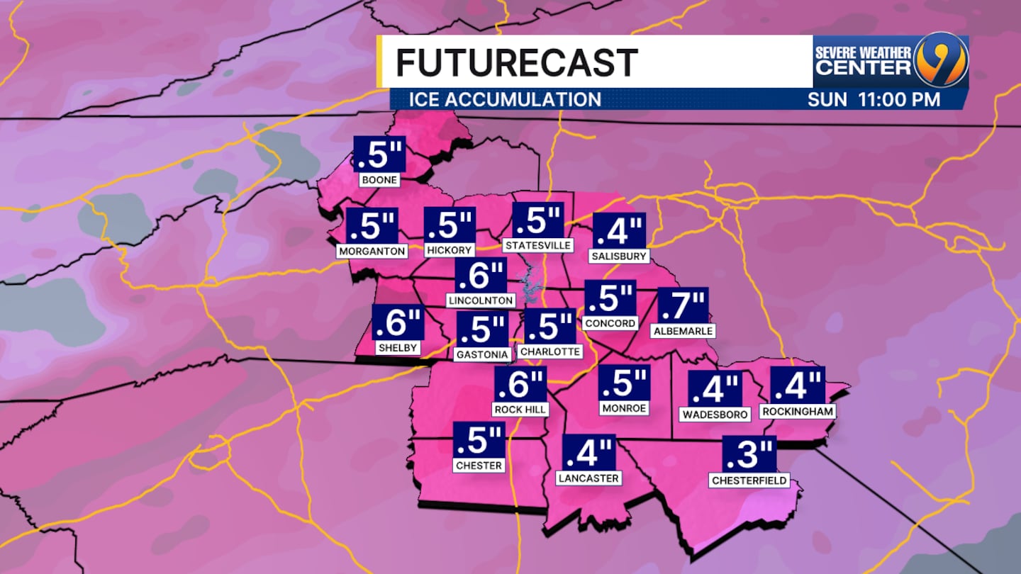
- Freezing rain continues for most of the day Sunday.
- A few rain showers are also possible as this system wraps up tomorrow evening.
- Ice totals are still on track with 0.25″-0.50″ expected southeast of Charlotte, and 0.50″+ possible around and north of the metro area.
- Sleet accumulations of an inch or greater are also possible north of the city.
- Dangerous travel is expected through the weekend with power outages likely as ice accumulates throughout the day Sunday.
- We’ll dry out overnight Sunday with temperatures sitting around the freezing mark.
- Bitter cold then moves in Monday night with temperatures in the single digits for some by Tuesday morning.
>> Channel 9’s Weather 24/7 stream has the latest local weather all day, every day. Watch wherever you stream — on our website, or through your mobile app or smart TV.
WEATHER RESOURCES:
- WSOC Weather 24/7
- Interactive Radar
- Download our weather app for Severe Weather Alerts
- Hour-by-Hour Forecast
- 7-Day Forecast
FOLLOW OUR TEAM ON X:
- Chief Meteorologist John Ahrens
- Meteorologist Keith Monday
- Meteorologist Joe Puma
- Meteorologist Danielle Miller
©2026 Cox Media Group
/cloudfront-us-east-1.images.arcpublishing.com/cmg/LH3JSJEF3VBLRJLJQESEAG34AM.png)


