CHARLOTTE — BELOW: The latest updates from Severe Weather Center 9. To stay on top of severe weather conditions, be sure to download our free WSOC-TV weather app.
Severe weather cleared out of the area Monday afternoon, but it left some damage behind. Showers will continue as temperatures are expected to drop overnight. Lows will be around 30 degrees in Charlotte.
STORM UPDATES:
2 p.m. - The National Weather Service confirmed a low-level tornado hit Charlotte, causing damage to several storms.
The NWS paid a visit to Charlotte following storm and possible tornado activity in the area on Monday morning.
Click here for more information.
#BREAKING: @NWSGSP just confirmed a brief tornado did touch down in Charlotte this morning. They gave it a preliminary rating of EF-0 with winds of 85 mph. It was 25 yards wide and on the ground for 1.5 miles. This is some of the damage from that tornado on Atando Ave. @wsoctv pic.twitter.com/gfyfMAgVsa
— Joe Puma (@JoePumaWSOC9) March 16, 2026
NOON — Mecklenburg County latest weather updates
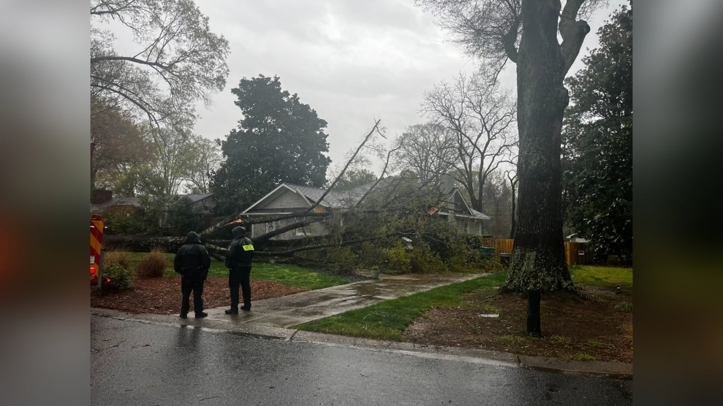
- A tree is reported to be down on Guilford Road in the Sedgefield neighborhood.
- Fire crews are on scene.
- Channel 9′ Eli Brand learned the home’s resident was not there at the time the tree fell. She is safe. She did have a dog at home, but the dog is also okay.
- The wet ground caused the roots to give out, leading to the tree falling.
- Neighbors came over to see if the homeowner was okay. They told Channel 9 that this was a wake-up call, and they will be having their trees inspected by experts.
NOON— Gaston County latest weather updates
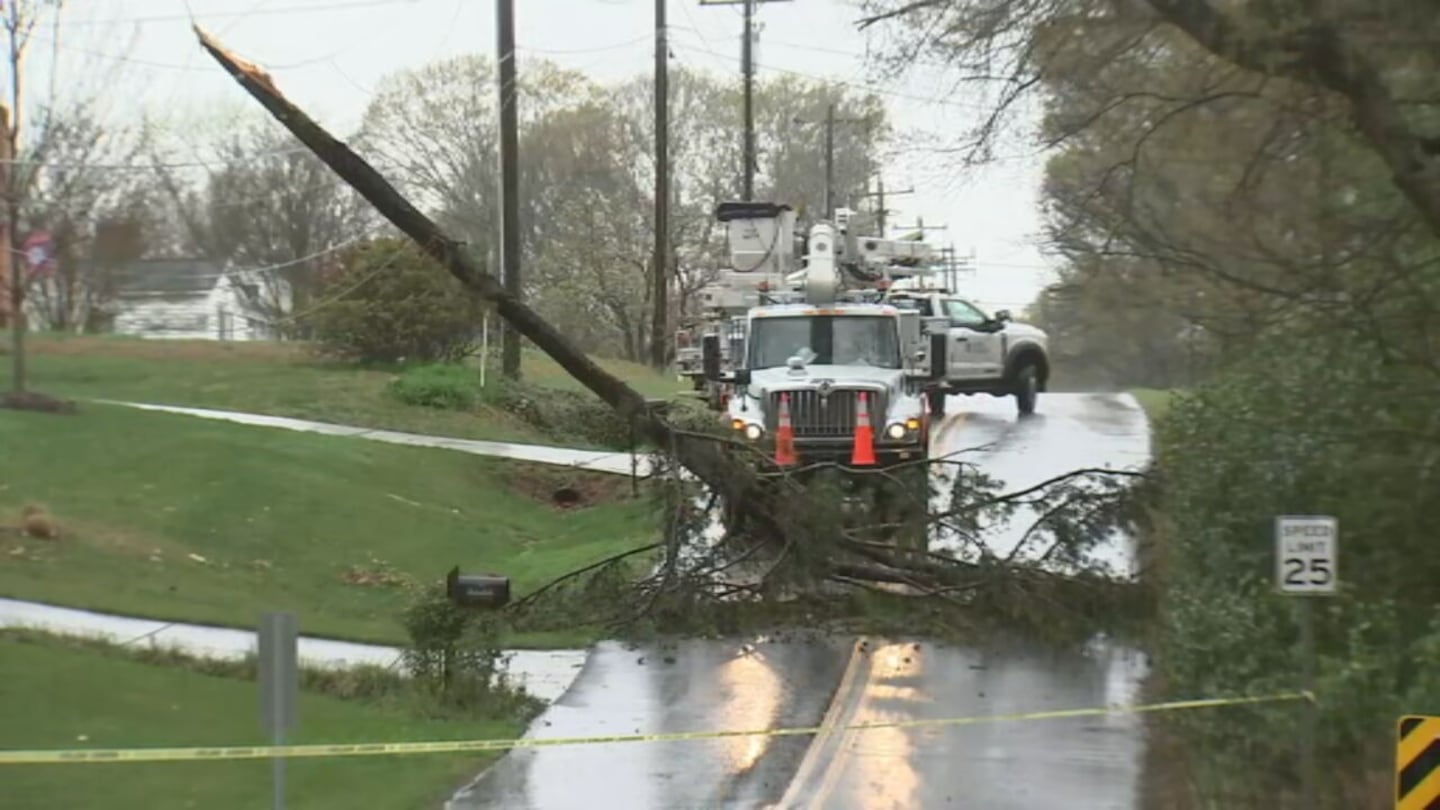
- A tree is reported to be down on Julia Avenue in Gaston County.
- Crews are on scene.
- Julia Avenue is a residential road that connects the Gastonia and Cramerton Communities.
- The large limb that ripped from the tree completely blocked the road.
- Part of the tree landed on a power line.
- Neighbors told Channel 9’s Ken Lemon that there was a sudden blast of wind and rain that hit the Belmont area just after 9 a.m.
- 911 dispatch said several trees fell across Gaston County
- About 737 people are without power in Gaston County.
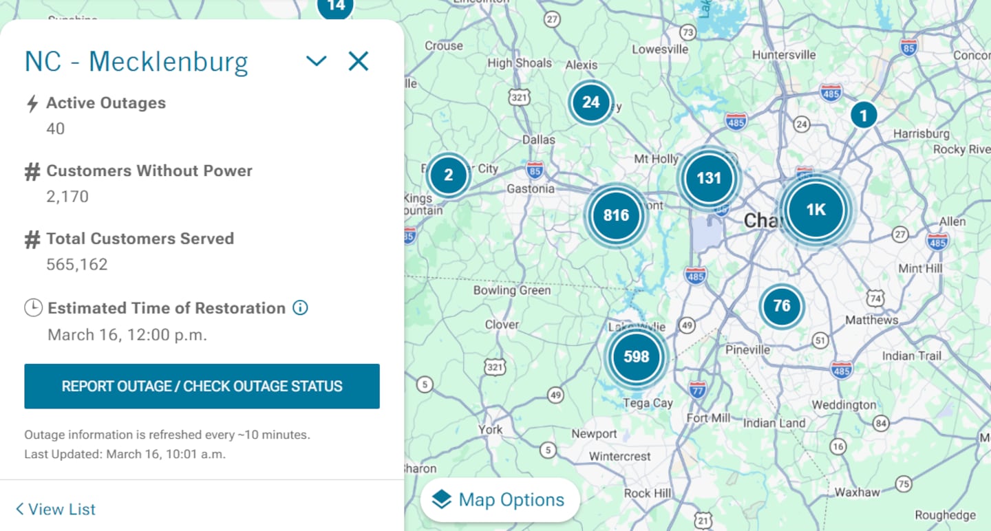
10:50 a.m. — Mecklenburg County power outages
- Duke Energy now reports as many as 4,588 customers are without power
- Power is expected to be restored by 3:20 p.m.

10:35 a.m. — Tornado warning in Stanly County
- A Tornado warning has been issued for Stanly County.
- The warning is expected to last until 11 a.m.
10:25 a.m. — Cabarrus County latest weather updates
- The tornado warning has been lifted for Cabarrus County
10:10 a.m. — Mecklenburg County power outages
- Duke Energy reports 40 active outages in Mecklenburg County
- 2,170 Duke customers are without power, the energy company reports
- Officials expect power to be restored by noon.
10:05 a.m. — Tornado Warning updates in Mecklenburg County
- Tornado Warning has been canceled for Mecklenburg County
10 a.m. — Tornado Warning updates in Cabarrus County
- NWS reports ongoing Tornado Warning, with the radar indicating a tornado, southeast of Concord
- Pea-sized hail is possible
- Warning continues until 10:15 a.m.
Tornado Warning continues for Concord NC until 10:15 AM EDT pic.twitter.com/9qrjuqgD39
— NWS Tornado (@NWStornado) March 16, 2026
9:45 a.m. — Tornado Warning in Mecklenburg and Cabarrus Counties
- Tornado warning issued for Mecklenburg and Cabarrus Counties, lasting until 10:15 a.m.
- Warning issued through Uptown, University City, Plaza Midwood, Newell, Druid Hills, NoDa, and Concord areas.
9:05 a.m. — Latest updates on incoming thunderstorms, possible tornadoes
- Tornado watch issued for Richmond, Stanly, and Anson Counties.
- Severe Thunderstorm warning issued for Mecklenburg, Cabarrus, Gaston, and Lincoln Counties.
A Tornado Wwarning has been issued for the highlighted area. If you are located within this warning, seek shelter now. More info at https://t.co/ticb9BnUvO pic.twitter.com/MxBBUV28RY
— Danielle Miller (@wx_danielle) March 16, 2026
9 a.m. — Latest updates at Charlotte-Douglas International Airport
- The FAA issued a second ground stop of the day at CLT
- The stop is effective starting at 8:30 a.m., continuing until at least 10 a.m.
- Officials say the stop was issued due to thunderstorms, with a chance of the stop being extended.
CharMeckALERT: EXTREME WIND & TORNADO RISK TODAY
— Charlotte-Mecklenburg Emergency Management (@CharMeckEM) March 16, 2026
Charlotte-Mecklenburg is at extreme risk for severe winds and possible tornadoes today. Wind gusts may be up to 30 mph throughout the day.
Remember:
If a tornado WATCH is issued, find your "safe space". Look for an interior room…
9 a.m. — Latest updates in Cleveland County
- Tornado warning has been canceled for Cleveland County

8:45 a.m. — Latest updates in Burke County
- A tree is down in Burke County along Highway 70, west of Glen Alpine, Burke 911 reports
8:30 a.m. — The latest forecast with Meteorologist Keith Monday
- A Tornado Warning has been issued for Cleveland County, continuing until 9 a.m.
- A Tornado Watch has been issued for Chesterfield County, continuing until 9 a.m.
Severe threats include damaging winds and tornadoes this morning. Some large hail is also possible along with torrential downpours. Be safe this morning! pic.twitter.com/6rWSq87XWy
— Keith Monday (@kmondayWSOC9) March 16, 2026
6 a.m. — FORECAST: Carolinas under Severe Thunderstorm Watch; tracking damaging winds, possible tornadoes
- We are on track for a threat of severe weather today across our region.
- A large line of storms moving in from the west arrives by late morning and then races across the entire viewing area.
- Damaging winds and tornadoes are the main threats, but some large hail is also possible.
- The worst weather moves east by the early afternoon, but rain continues long after with gusty winds.
- Temps stay in the 60s most of the day before dropping into the 50s late afternoon.
- The mountains will see a changeover from rain to snow this afternoon. A Winter Weather Advisory is in place up there tonight.
- Several inches possible at the highest ridgetops but lower elevations just seeing a little coating.
- Bitter cold tonight with temps below freezing areawide.
- We only warm to the upper 40s with sunshine on St Patrick’s Day.
- Warmer weather returns by the end of the week as we stay dry and quiet.
A Severe Thunderstorm Watch has been issued for most of our area until 11 am. Storms arriving from the west later this morning will bring in damaging winds and even a tornado threat. This threat will ease up after midday and shift east.
— Keith Monday (@kmondayWSOC9) March 16, 2026
Stay alert this morning as storms arrive. pic.twitter.com/cfOhLFFaaP
FORECAST: Carolinas under Severe Thunderstorm Watch; tracking damaging winds, possible tornadoes

©2026 Cox Media Group

/cloudfront-us-east-1.images.arcpublishing.com/cmg/LH3JSJEF3VBLRJLJQESEAG34AM.png)


