ATLANTIC BEACH, N.C. — Lifeguards in Atlantic Beach told Channel 9’s Ken Lemon Wednesday that they are on alert as Hurricane Erin prepares to hit the North Carolina coast.
Lifeguard Tanner Murray said he has noticed swimmers too far out in the ocean.
Heavy surf and rip currents easily pull swimmers out to sea without notice.
Those currents have already caused deaths in the northern Atlantic.
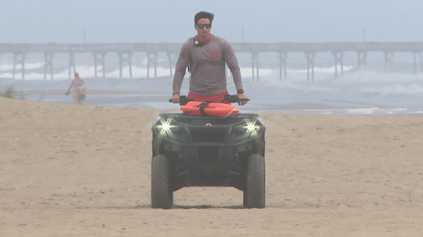
“People really underestimate the rips out here,” said Murray. “It can take in out in like 20 seconds without you ever realizing it, because you are just floating there and the swells are supposed to get 10-15 foot.”
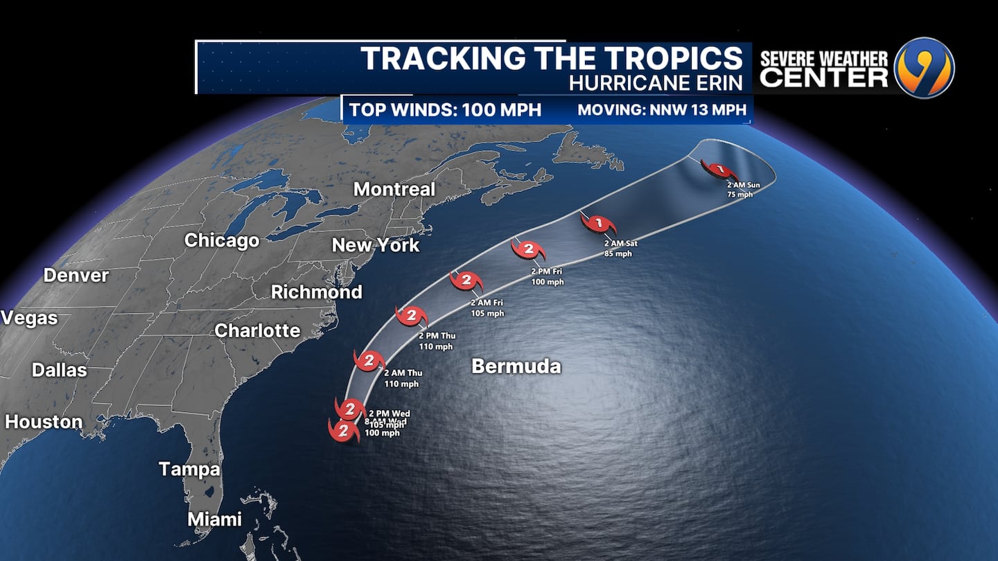
Hurricane Erin sits just off the Southeast Coast this morning as a category 2 hurricane. The storm is starting it's turn north and eventually northeast over the next few days. We'll be monitoring the Outer Banks for gusty winds, rough surf and flooding issues due to storm surge. pic.twitter.com/5beIlPPq1o
— Danielle Miller (@wx_danielle) August 20, 2025
Officials are also worried that the hurricane could slow down offshore or nudge a bit toward shore before shifting away, which could cause a lot of rainfall.
People there were feeling the wind whipping on shore, stirring the waves, on Wednesday afternoon.
They expect the swells to reach about 12 feet.
The worry is the tidal surge, which could cause local flooding if high tide increases another 2-3 feet, according to the fire chief.
He and others hope Hurricane Erin moves quickly.
People here have seen storms suddenly slow down.
They hope that doesn’t happen this time.
“This is the calm before the storm,” resident Chad Sittig. “The storms are so unpredictable. They can take a left. They can take a right. They can speed up. They can slow down. You don’t really know until it’s actually here.”
Dozens of beach homes already worn down from chronic beach erosion and the loss of protective dunes could be at risk, said David Hallac, superintendent of the Cape Hatteras National Seashore.
Picking up steam
Hurricane Erin began strengthening again Wednesday while creeping toward the mid-Atlantic coast and churning up menacing waves that have closed beaches from the Carolinas to New York City, The Associated Press reported.
Forecasters expect the storm to peak over the next 48 hours and say it could re-intensify into a major hurricane by Wednesday night.
While Erin is unlikely to make landfall along the East Coast before turning farther out to sea, authorities expect its large swells will cut off roads to villages and vacation homes on North Carolina’s Outer Banks and whip up life-threatening rip currents from Florida to New England.
Erin remained a strong Category 2 hurricane on Wednesday with maximum sustained winds around 110 mph, the National Hurricane Center said. It was about 365 miles south-southeast of North Carolina’s Cape Hatteras.
Tropical storm warnings were issued for North Carolina and Virginia, while in Bermuda the government warned residents and tourists to stay out of the water, as rough seas are expected through Friday.
NASA pilot program
NASA has launched the Response Mapper program to aid hurricane disaster recovery by utilizing citizen science.
The program encourages the public to submit before-and-after photos of affected areas to help track ground conditions.
According to ABC News, the space agency is leading this initiative to enhance data collection for emergency responders.
Participants can contribute by downloading the GLOBE Observer app on their smartphones and joining the NASA Response Mappers team.
The app allows users to take land cover photos of the same location over time, ideally once a week or month, to monitor changes.
The Response Mapper program will run through October 31.
The Associated Press contributed to this report.
VIDEO: Wednesday morning’s forecast with Meteorologist Keith Monday

©2025 Cox Media Group
/cloudfront-us-east-1.images.arcpublishing.com/cmg/LH3JSJEF3VBLRJLJQESEAG34AM.png)


